

Dec 1 2025
Please contact us to place an order or for information on Canadian topo maps or custom orders
Thank you
June 1 2024
We have had to discontinue lamination services until further notice. Please do not select a laminated map in our sales module until we have the situation rectified!
April 2023
Our retail store is now closed.
Topographic map sales and custom orders are still available online and by phone.
PLEASE NOTE: SHIPPING COSTS ARE RISING DRAMATICALLY WE MAY HAVE TO SEND YOU A SEPERATE INVOICE FROM PAYPAL TO COVER THE ADDITIONAL SHIPPING SURCHARGES WE INCUR
Large Format plotting service available
please contact us for information
We are a Certified Map Printer for NRCan providing print on demand service for Canadian Mapping
Custom Cartography
Wall Maps Street Maps
Antique Maps Antique Map Reproductions
Canada post adds $1.50 to shipping in tube rates, sorry
News....
Retail In Store Operations are now closed!! Custom Services are still available
2018 version is sold out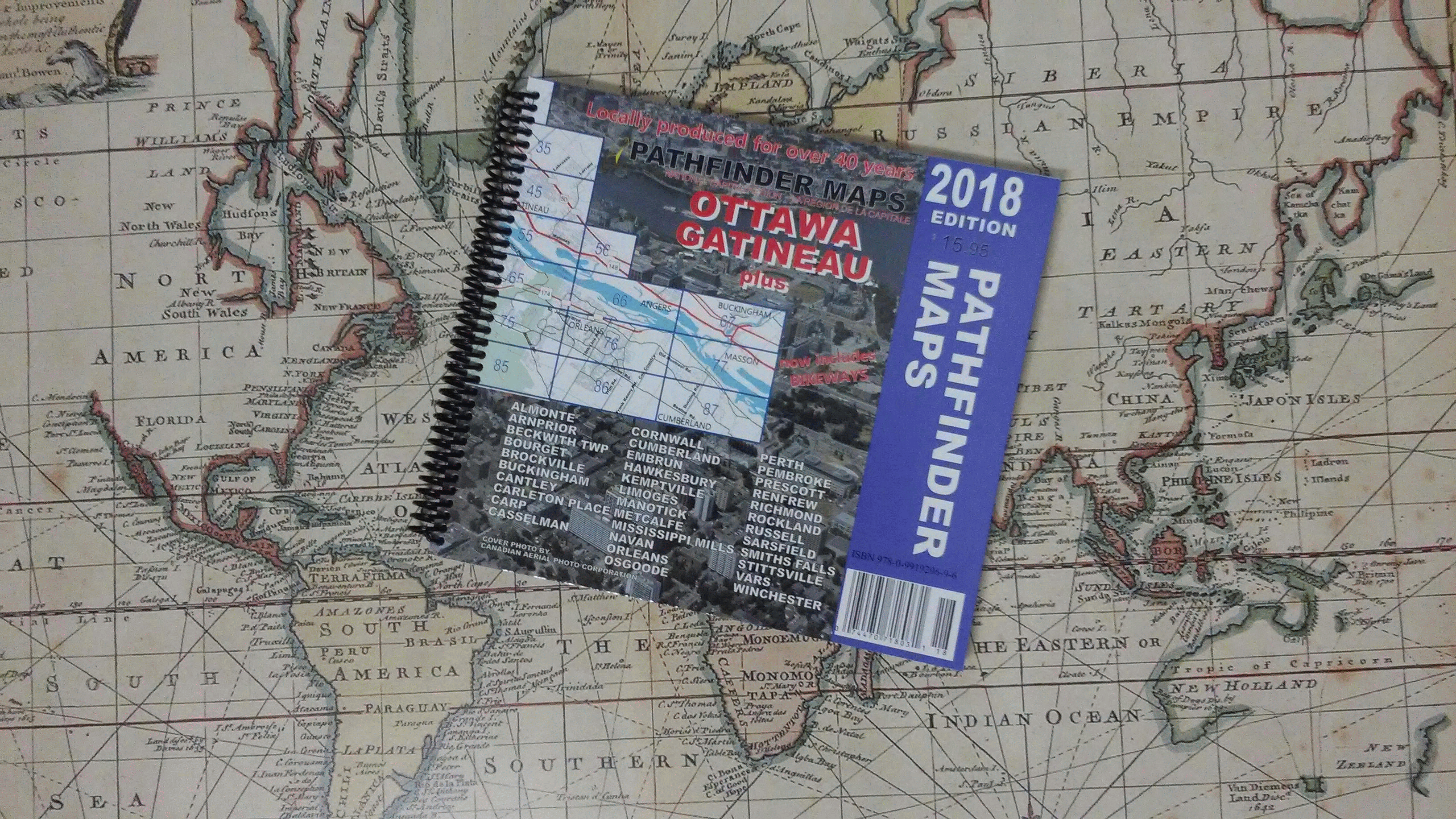
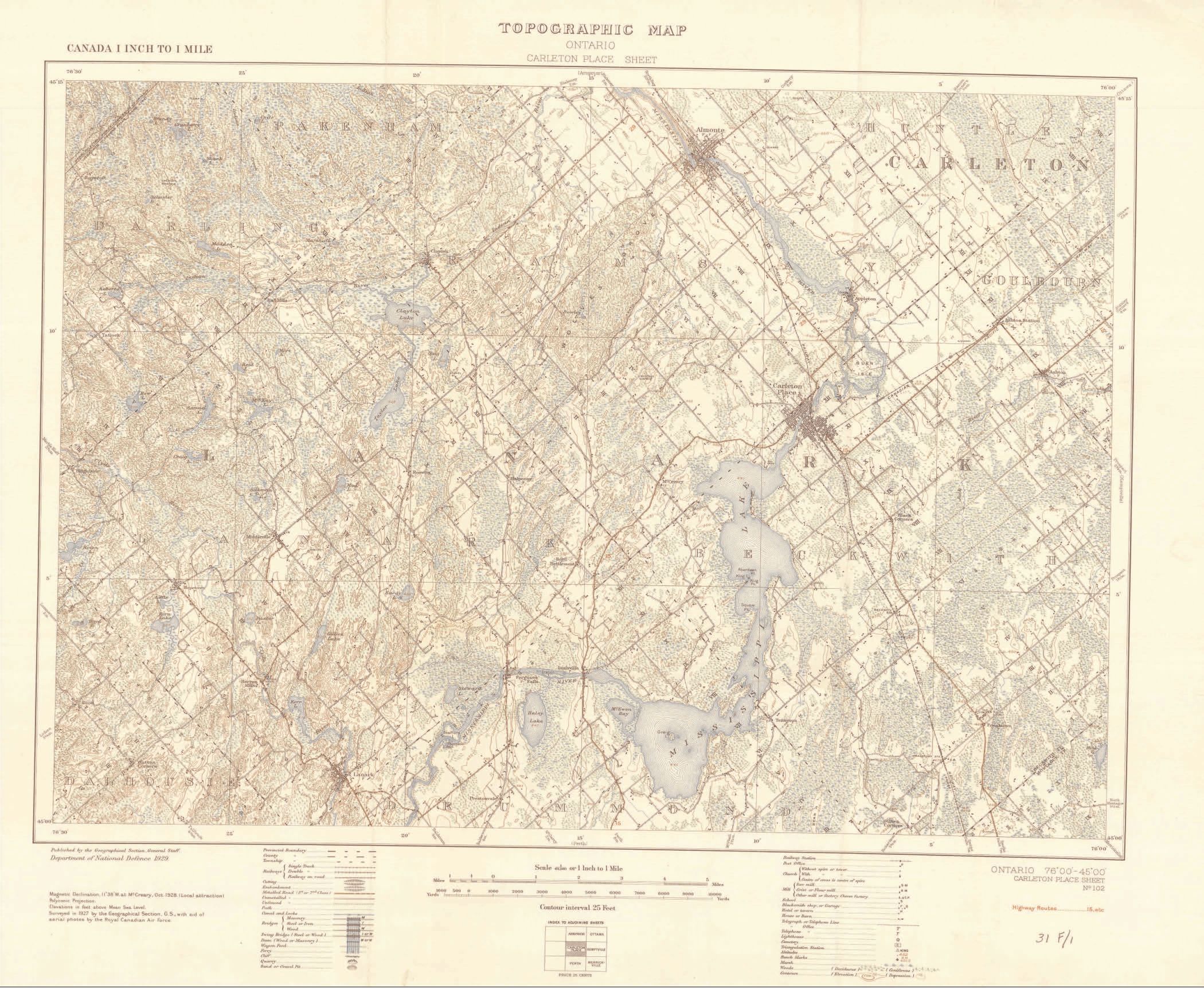
The Mississippi River in Ontario display map
April 2017 2017 edition of the Ottawa Gatineau Book Map and Wall map are released
November 2016 RIDGETEC trail cameras have arrived
Palmerston Lake Bass Derby June 18 and 19 2016
February 2016 2016 edition of the Ottawa Gatineau Book Map and wall map are released
April 2015 Natural Resources Canada releases a revised map of Canada - MCR 102
March 2015 2015 edition of the Ottawa Gatineau Book Map and wall map are released
April 2014 2014 edition of the Ottawa Gatineau wall map is released
March 2014 2014 Edition of the Ottawa Gatineau Book Map is released
February 2014 Pathfinder Maps Launches our new Web site and online store.
March 2013 Pathfinder Maps 2013 Ottawa Gatineau Book Map and Wall Map are released
April 2012 Pathfinder Maps becomes a dealer for Scorpion Optics
Feb., 2012 Pathfinder Maps 2012 Ottawa Gatineau Book Map and Wall Map are released
March, 2011 Pathfinder Maps 2011 Ottawa Gatineau Book Map and Wall Map are released
June, 2010 Pathfinder Maps becomes a Certified Map Printer for Natural Resources Canada
March, 2010 Pathfinder Maps 2010 Ottawa Gatineau Book Map is released
March, 2009 Pathfinder Maps 2010 Ottawa Gatineau Wall Map is released
March, 2009 Pathfinder Maps 2009 Ottawa Gatineau Book Map is released, finally sorry about the delay!!
February, 2009 Pathfinder Maps 2009 Ottawa Gatineau Wall Map is released
March, 2008 All Star Rods are now in stock
January, 2008 Pathfinder Maps 2008 edition Ottawa-Gatineau Plus™ book map and wall map released.
April 20, 2007 Pathfinder Maps ATV map for Northern Frontenac County is released.
March 27, 2007 Canada Post has put a $1.00 surcharge on mailing tubes, so our rates have to be adjusted accordingly, sorry.
March1, 2007 Pathfinder Maps delivers the 2007 edition of their Ottawa district map to the Ottawa Real Estate Board
Feb. 26, 2007 Pathfinder Maps 2007 edition Ottawa-Gatineau Plus™ book map released.
Feb. 1, 2007 Pathfinder Maps 2007 edition Ottawa Wall Map released
October 12, 2006 Natural Resources Canada scraps closure of Canada Map Office
January 12, 2006 Pathfinder Maps Ottawa-Gatineau Plus™ 2006 edition book map released.
December 01, 2005 MapEdge™ has been updated as of Nov. 15, 2005.
November 20, 2005 Pathfinder Maps and PATHFINDER MapEdge™profiled on CJOH-TV Tech Now.
October 01, 2005 Pathfinder Maps retail store in Carleton Place, ON undergoes a major expansion making room for a larger display of Optics, Outdoor Wear and Inflatable Canoes and Kayaks.
March 11, 2005 Pathfinder Maps Ottawa-Gatineau Plus™ 2005 edition book map released.
March 10, 2005 TableEdge™ released. This program provides a calculator style AND spreadsheet style user interface for converting between MTM, UTM and Latitude/Longitude coordinate systems. It also provides large table re-organization capabilities such as multi-column sort and export of selected columns. Works with comma delimited files.
March 01, 2005 MapEdge™ has been updated as of Feb. 15, 2005.
Jan 19, 2005 MapEdge™ has been updated and repackaged. Ottawa street and address point data is now up to date as of Jan 15, 2005. MapEdge™ Lookup allows you to find the newest addresses in Ottawa instantly and accurately. pin-pointing them on air photos and vector maps. MapEdge™ Analyst is available for those who need more comprehensive analytical functions as well as copy/paste access to the air photos. (Address locations are pin-pointed accurately in MapEdge™, unlike competitors who estimate address locations - quite often showing a wrong location.)
Nov. 29, 2004 Pathfinder MapEdge™ MTM-UTM-Lat/Long Conversion calculator program with audit trail released. For all of Canada, a standalone, windows based MTM - UTM - Latitude/Longitude converter with an audit trail. Works for all 32 MTM zones in Canada. Easily convert from one of MTM, UTM or Latitude/Longitude to the other two with an on screen "calculator like" user interface. The on-screen audit trail keeps track of old MTM UTM conversions and allows copy and paste to other applications.
Nov 17, 2004 Pathfinder MapEdge™ updated to contain 250,000 individual, fully searchable, address points for all of Ottawa. These address points are up to date as of Oct. 15 2004. No longer do you have to rely on software estimating an address location. MapEdge(TM) pinpoints addresses in Ottawa and Gatineau using at total of 325,000 individual address points linked accurately to the 1 metre resolution air photos and street vector data.
Oct 1, 2004 Pathfinder MapEdge™ for OTTAWA/GATINEAU released. Dispatchers get the benefit of up to date data AND the ability to see what drivers see - through the air photos. Surveyors can find MTM, UTM and Latitude/Longitude points accurately on the air photos. Urban Planners and Consulting Engineers can measure lengths and areas accurately on the Air Photos and enhance presentations by including imagery at any scale. Security personnel can plan and respond much more effectively. MapEdge™ with air photos takes mapping to a stunningly useful and exciting new level.